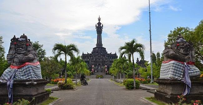
Denpasar city is also known as Kota Denpasar, the capital city of Bali, Indonesia. The name of Denpasar is coming from the Balinese word "den" which means the north and "pasar" means the market. This name was taken because it’s located just in the north of Kumbasari market.
Denpasar city was originally a center of Badung kingdom, and was conquered by the Dutch during the Dutch intervention in Bali (1906), it also remains the administrative center of the Regency of Badung and starting in 1958 it's become the seat of government for the province of Bali. Bali experienced unprecedented growth both in terms of physical, economic, social and cultural after Denpasar used as the center of government.
Denpasar is the seat of government, the center of commerce, education centers, industrial centers and tourist center that consists of 4 districts, namely West Denpasar, East Denpasar, South Denpasar, and North Denpasar.
The year is divided into two seasons: wet and dry. The wet season lasts roughly from November to April, while the dry season lasts from May to October. The temperatures are not extreme, but the heat, combined with the oppressive humidity and copious precipitation, makes the climate very uncomfortable at times.
Denpasar has the various attraction for a holiday. The white sandy beaches are well-known all over the island.  Sanur beach has calmer waters and is excellent for sunbathing and other water sports activities. And also in the center of Denpasar city has several tourist attractions and places of interest such as Bali Museum, Bajra Sandhi Monument (Renon), Puputan Badung Monument and Denpasar square, Taman Budaya Ardha Chandra (Bali Art Centre).
Ten minutes from the Ngurah Rai International Airport lies the town of Kuta. Kuta is where the most of the accommodation such as hotels, restaurants, malls, cafes, marketplaces, shopping center and spas that cater to tourists are located. In the Denpasar area, all kinds of Balinese handicrafts are represented in local shops. These include artwork, pottery, textiles, and silver.
Official site : www.denpasarkota.go.id
| Contens | ||||
| Capital of Bali Province | Geography | Climate | Tourism | Map |
Capital of Bali Province
Denpasar is the seat of government, the center of commerce, education centers, industrial centers and tourist center that consists of 4 districts, namely West Denpasar, East Denpasar, South Denpasar, and North Denpasar.
Geography
Denpasar City is located at an altitude of 0-75 m above sea level. With total area 127.78 km² or 2.18% of the total area of Bali Province. From the use of land, 2768 hectares of land are rice fields, 10,001 hectares is dry land and the remaining land area of 9 hectares is for other uses.Climate
Denpasar, located just in the south of the equator, it has a tropical wet and dry climate, with hot and humid weather throughout the year and little temperature change throughout the year. Unlike many cities outside Indonesia with this climate, there is very little seasonal temperature change, with temperatures averaging about 28°c.The year is divided into two seasons: wet and dry. The wet season lasts roughly from November to April, while the dry season lasts from May to October. The temperatures are not extreme, but the heat, combined with the oppressive humidity and copious precipitation, makes the climate very uncomfortable at times.
Tourism
 Sanur beach has calmer waters and is excellent for sunbathing and other water sports activities. And also in the center of Denpasar city has several tourist attractions and places of interest such as Bali Museum, Bajra Sandhi Monument (Renon), Puputan Badung Monument and Denpasar square, Taman Budaya Ardha Chandra (Bali Art Centre).
Ten minutes from the Ngurah Rai International Airport lies the town of Kuta. Kuta is where the most of the accommodation such as hotels, restaurants, malls, cafes, marketplaces, shopping center and spas that cater to tourists are located. In the Denpasar area, all kinds of Balinese handicrafts are represented in local shops. These include artwork, pottery, textiles, and silver.
Map
Location and Map of Denpasar City Bali Indonesia powered by Google MapsOfficial site : www.denpasarkota.go.id


 English
 Bahasa Indonesia
Comments